


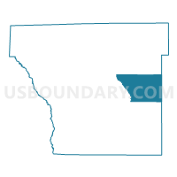
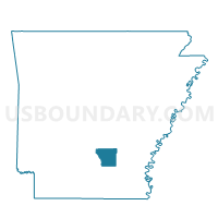
Rowell Voting District, Cleveland County, Arkansas
About
Outline

Summary
| Unique Area Identifier | 526177 |
| Name | Rowell Voting District |
| County | Cleveland County |
| State | Arkansas |
| Area (square miles) | 34.58 |
| Land Area (square miles) | 34.56 |
| Water Area (square miles) | 0.01 |
| % of Land Area | 99.96 |
| % of Water Area | 0.04 |
| Latitude of the Internal Point | 33.89501080 |
| Longtitude of the Internal Point | -92.03597780 |
Maps

Graphs
Select a template below for downloading or customizing gragh for Rowell Voting District, Cleveland County, Arkansas


Neighbors
Neighoring Voting District (by Name) Neighboring Voting District on the Map
- Harper Voting District, Cleveland County, AR
- Hudgin Voting District, Cleveland County, AR
- Mill Creek Voting District, Lincoln County, AR
- Miller Voting District, Cleveland County, AR
- Owen Palmyra Voting District, Lincoln County, AR
- Smith Voting District, Cleveland County, AR
Top 10 Neighboring County Subdivision (by Population) Neighboring County Subdivision on the Map
- Owen township, Lincoln County, AR (1,204)
- Miller township, Cleveland County, AR (663)
- Harper township, Cleveland County, AR (538)
- Smith township, Cleveland County, AR (424)
- Rowell township, Cleveland County, AR (395)
- Hudgin township, Cleveland County, AR (325)
- Mill Creek township, Lincoln County, AR (317)
Top 10 Neighboring Unified School District (by Population) Neighboring Unified School District on the Map
- Star City School District, AR (9,208)
- Cleveland County School District, AR (5,521)
- Woodlawn School District, AR (2,849)